
Demo Project 2 · Pittsboro, North Carolina
Pittsboro Property Screening
Ten exhibits. One clearer picture of the property. Explore how access, water, terrain, soils and planning context fit together—and which questions deserve closer investigation.
View / download the Pittsboro report (PDF; opens in a new tab)
This completed demonstration project illustrates a broader screening workflow. See the free report page for its scope and details. Select any exhibit below to open the full-size image in a new tab.
Exhibit 01 · Parcel context
Establish the property’s starting point.
The mapped parcel provides a common frame for every exhibit that follows. GIS measurements show 23.857 acres, while the county record reports 24.549 deeded acres—an important distinction when comparing mapped and recorded information.
 EX01 · Parcel context
Open full-size image ↗ (new tab)
EX01 · Parcel context
Open full-size image ↗ (new tab)
Exhibit 02 · Road proximity & access
Being near a road is not the same as having access.
The mapped parcel boundary is about 98.43 feet from the Rock Springs Road alignment. That separation raises a practical follow-up question: what connects the property to the road, and what access rights have been documented?
 EX02 · Road proximity & access
Open full-size image ↗ (new tab)
EX02 · Road proximity & access
Open full-size image ↗ (new tab)
Exhibit 03 · Hydrology
Follow the water through the property.
A stream, mapped wetlands and a 50-foot analytical stream buffer form a connected corridor across the parcel. Seeing these features together helps identify where field review and more detailed investigation should be focused.
 EX03 · Hydrology
Open full-size image ↗ (new tab)
EX03 · Hydrology
Open full-size image ↗ (new tab)
Exhibit 04 · Terrain & slope
Locate the steeper ground before planning around it.
About 2.65 acres, or 11.1% of the classified parcel, exceed 15% slope. The map shows where those areas are distributed, helping frame questions about site layout, grading and further topographic investigation.
 EX04 · Terrain & slope
Open full-size image ↗ (new tab)
EX04 · Terrain & slope
Open full-size image ↗ (new tab)
Exhibit 05 · NRCS soil screening
Ask the right soil question for the intended use.
For septic tank absorption fields, published NRCS ratings map 7.89 acres (33.1%) as Very Limited and 15.97 acres (66.9%) as Somewhat Limited. These use-specific ratings help prioritize follow-up; they are not a general verdict on the property.
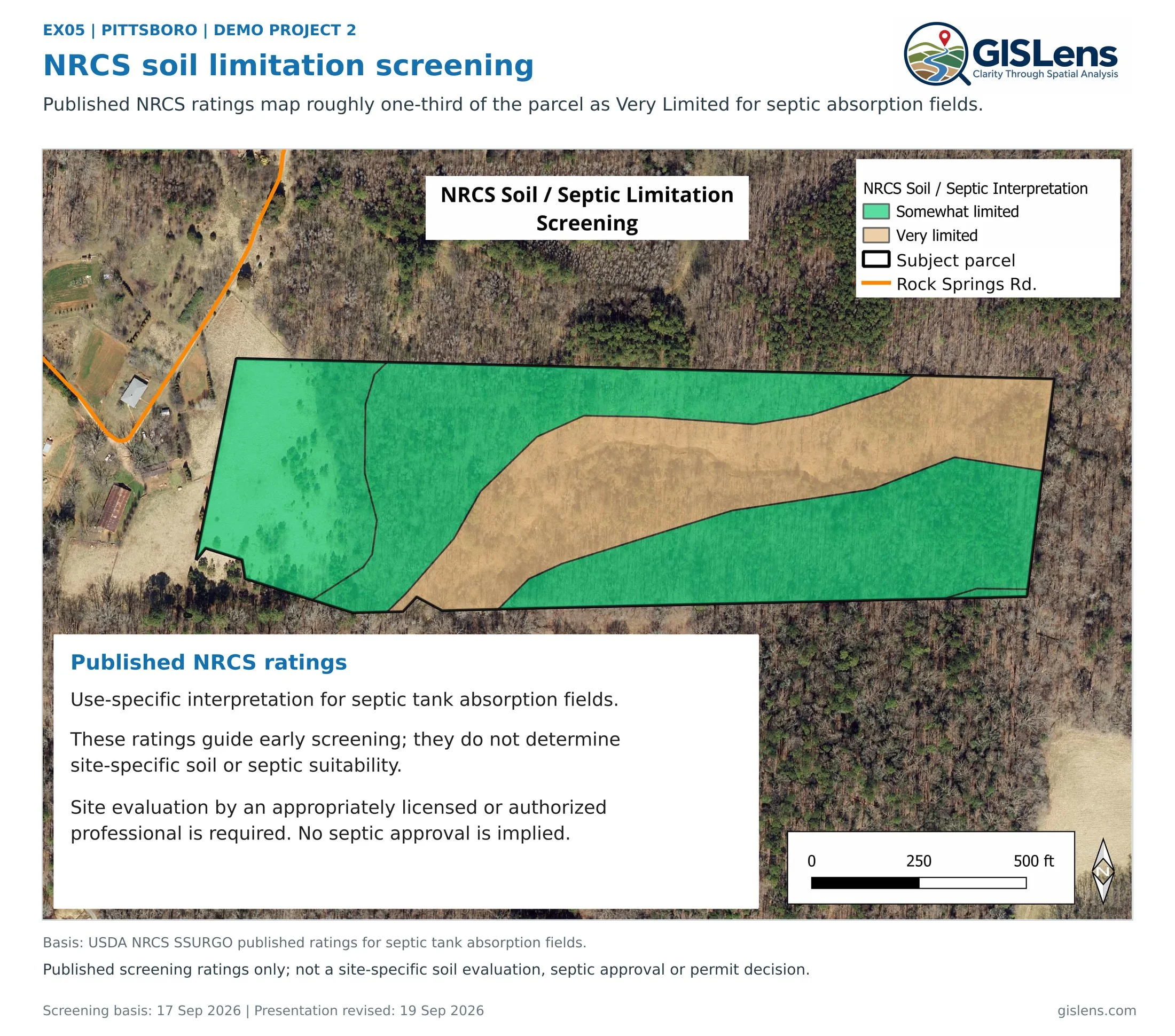 EX05 · NRCS soil screening
Open full-size image ↗ (new tab)
EX05 · NRCS soil screening
Open full-size image ↗ (new tab)
Exhibit 06 · Combined constraints
See how the selected constraints fit together.
This exhibit combines mapped wetlands, the 50-foot analytical stream buffer and slopes above 15%. The combined footprint helps focus investigation where these conditions overlap or extend across the property.
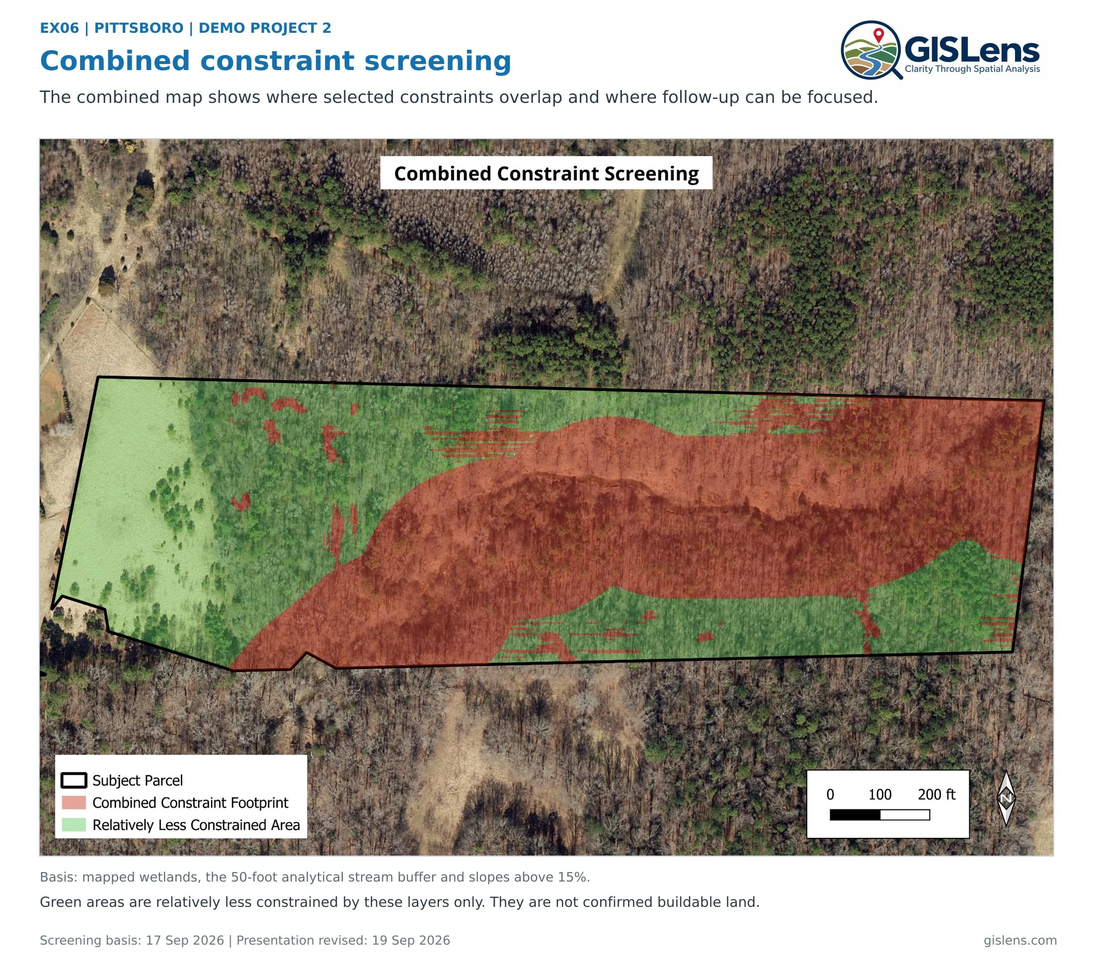 EX06 · Combined constraints
Open full-size image ↗ (new tab)
EX06 · Combined constraints
Open full-size image ↗ (new tab)
Exhibit 07 · FEMA flood screening
A negative finding still deserves a clear explanation.
No mapped FEMA flood-hazard feature intersected the parcel in the data reviewed. This documents the result for that particular screening layer while keeping other flooding and drainage questions in view.
 EX07 · FEMA flood screening
Open full-size image ↗ (new tab)
EX07 · FEMA flood screening
Open full-size image ↗ (new tab)
Exhibit 08 · Federal critical habitat
Separate a mapped habitat result from a wildlife conclusion.
The reviewed USFWS layers returned zero parcel intersections for both final and proposed federal critical habitat. That finding addresses those mapped designations—not whether protected species or other sensitive habitat are present.
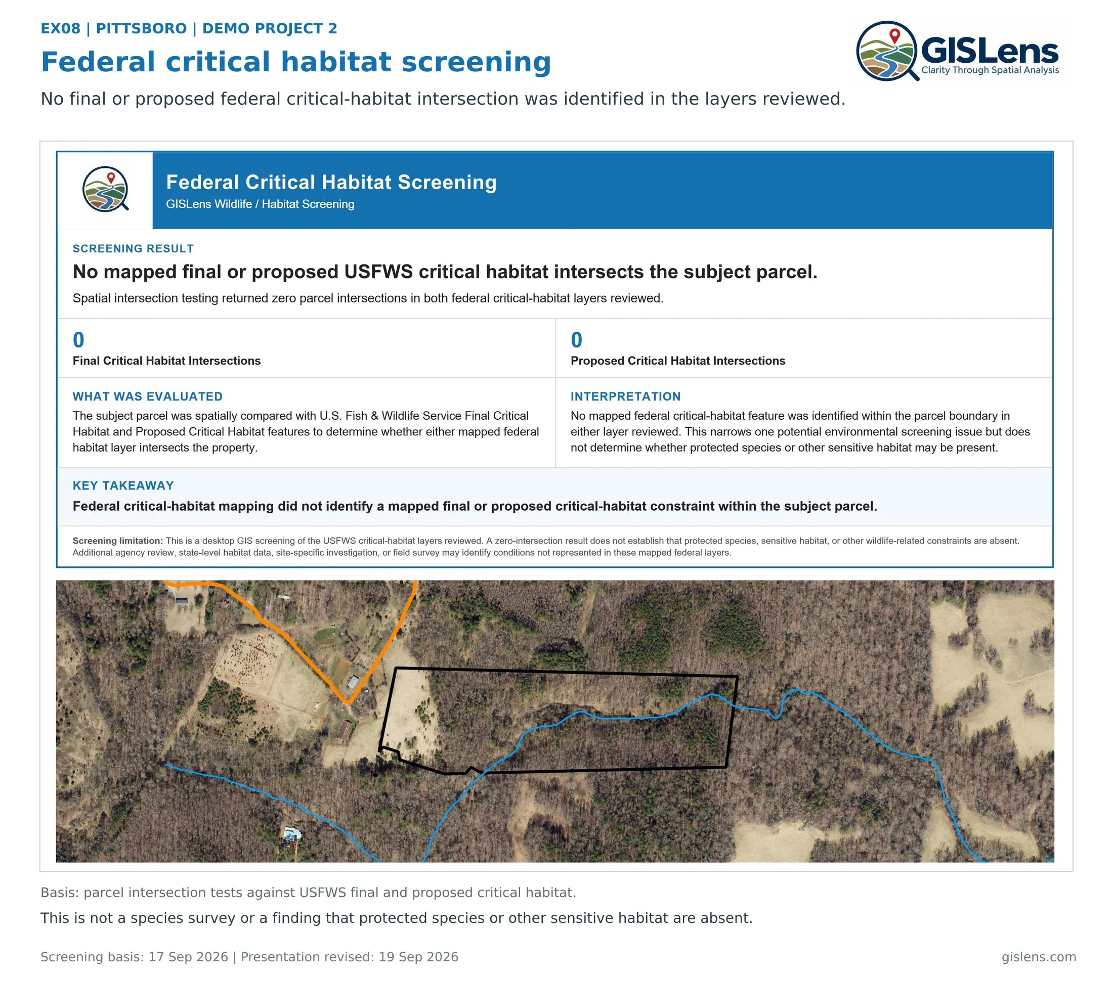 EX08 · Federal critical habitat
Open full-size image ↗ (new tab)
EX08 · Federal critical habitat
Open full-size image ↗ (new tab)
Exhibit 09 · Current zoning
Identify the zoning context—and what still needs confirmation.
The zoning layer reviewed for this project maps the parcel R-A2 within the Pittsboro extraterritorial jurisdiction (ETJ). The exhibit establishes a starting point for checking district standards, overlays and property-specific conditions.
 EX09 · Current zoning
Open full-size image ↗ (new tab)
EX09 · Current zoning
Open full-size image ↗ (new tab)
Exhibit 10 · Future land use & planning
Understand the planning setting beyond the parcel.
The surrounding future-land-use framework includes conservation, rural, parks and protected land, and a nearby Village Center. The parcel is shown within the Pittsboro ETJ, which identifies jurisdiction rather than a future land-use designation.
 EX10 · Future land use & planning
Open full-size image ↗ (new tab)
EX10 · Future land use & planning
Open full-size image ↗ (new tab)
Your property. Your next questions.
Start with a clearer picture.
Request a free property report to begin exploring your property’s mapped context. If you already have a specific question or need additional analysis, let’s discuss it.
View / download the Pittsboro report (PDF; opens in a new tab)
The free report’s scope is described on the request page; this ten-exhibit demo is a separate project example.