
GISLens · Sample Report
Pine County
See how planning restrictions, water features, terrain and published soil information come together to identify property questions and focus your next investigations.
Portfolio example. Names, addresses, county and source references are fictionalized. Maps and findings derive from a real study; geography may remain recognizable.
Exhibit 1
Property Overview
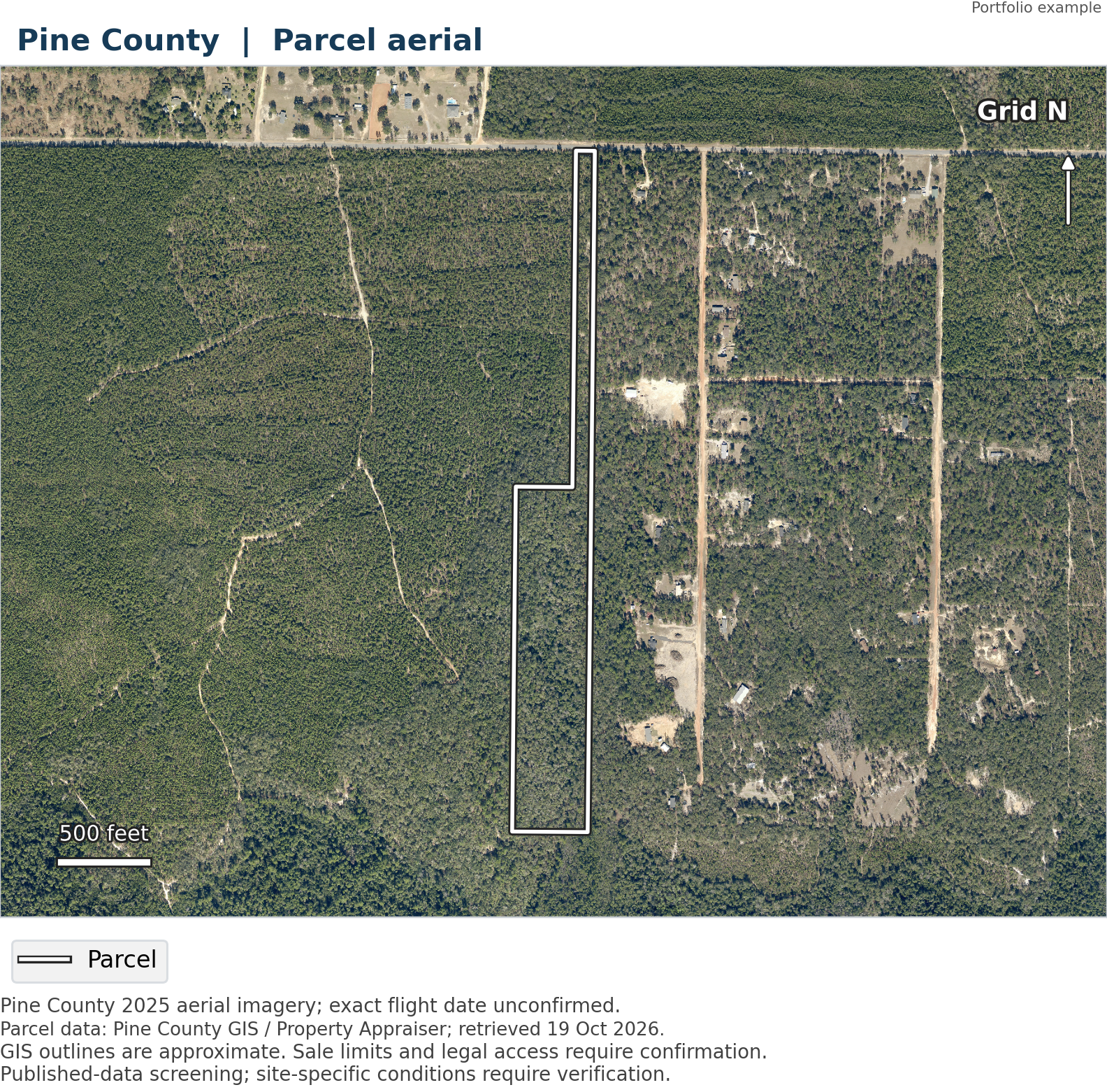
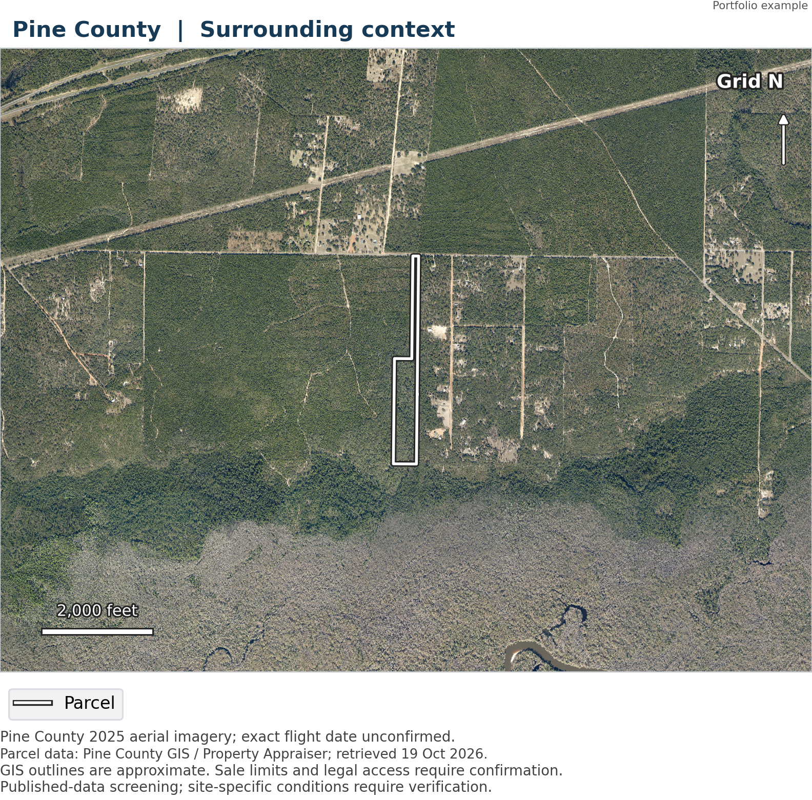
The screening covers one full county GIS parcel, extending from a narrow road-facing strip into a wider tract to the south.
Key takeaways
- Listed and county legal acreage is 25.00 acres; the mapped boundary calculates to approximately 25.23 acres.
- Confirm the offered tract, legal description, boundaries and access through survey and title review.
- Road proximity and a listing claim of frontage do not establish legal access.
Download the full report for parcel details and source records.
Exhibit 2
Zoning and Future Land Use
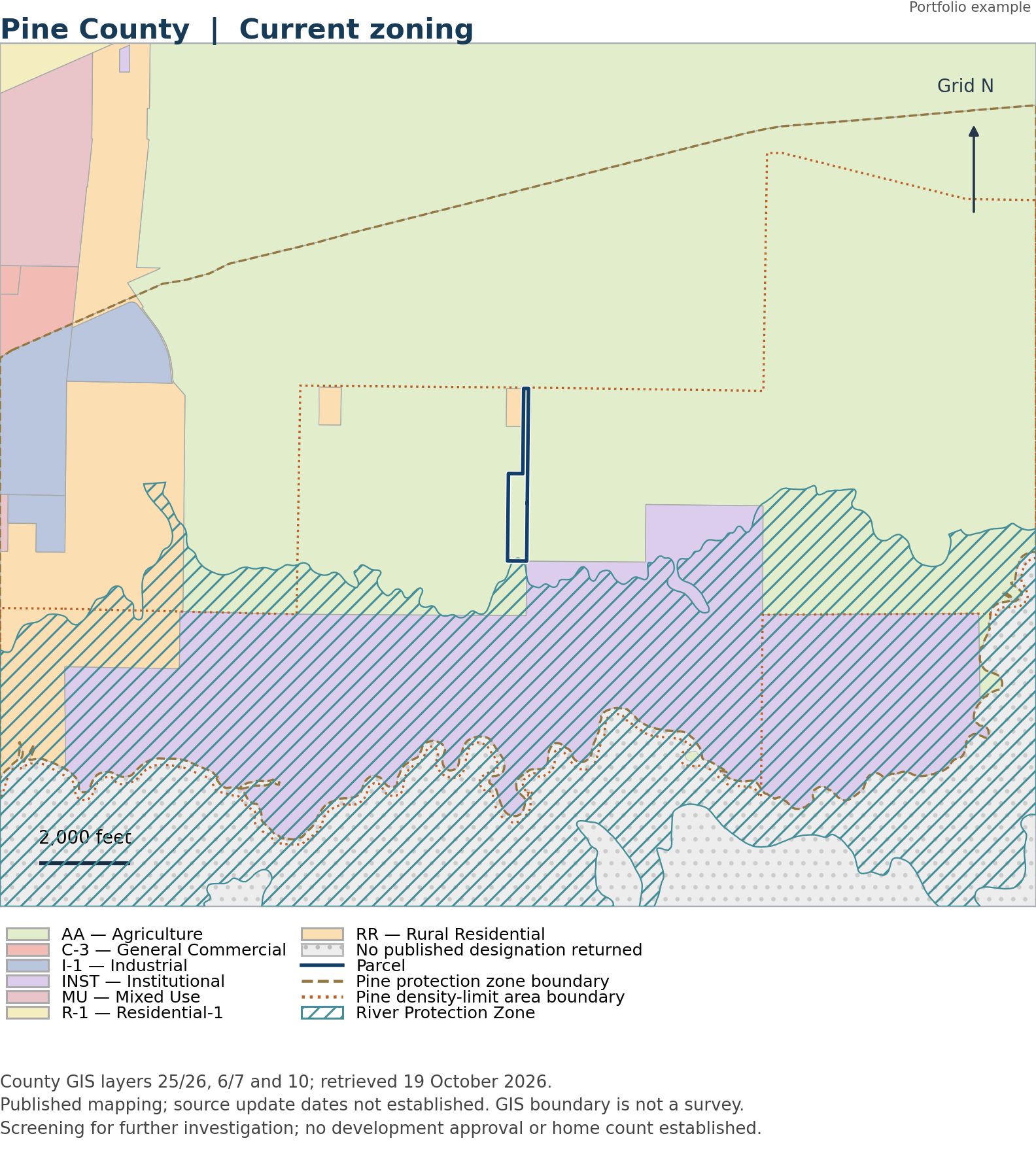
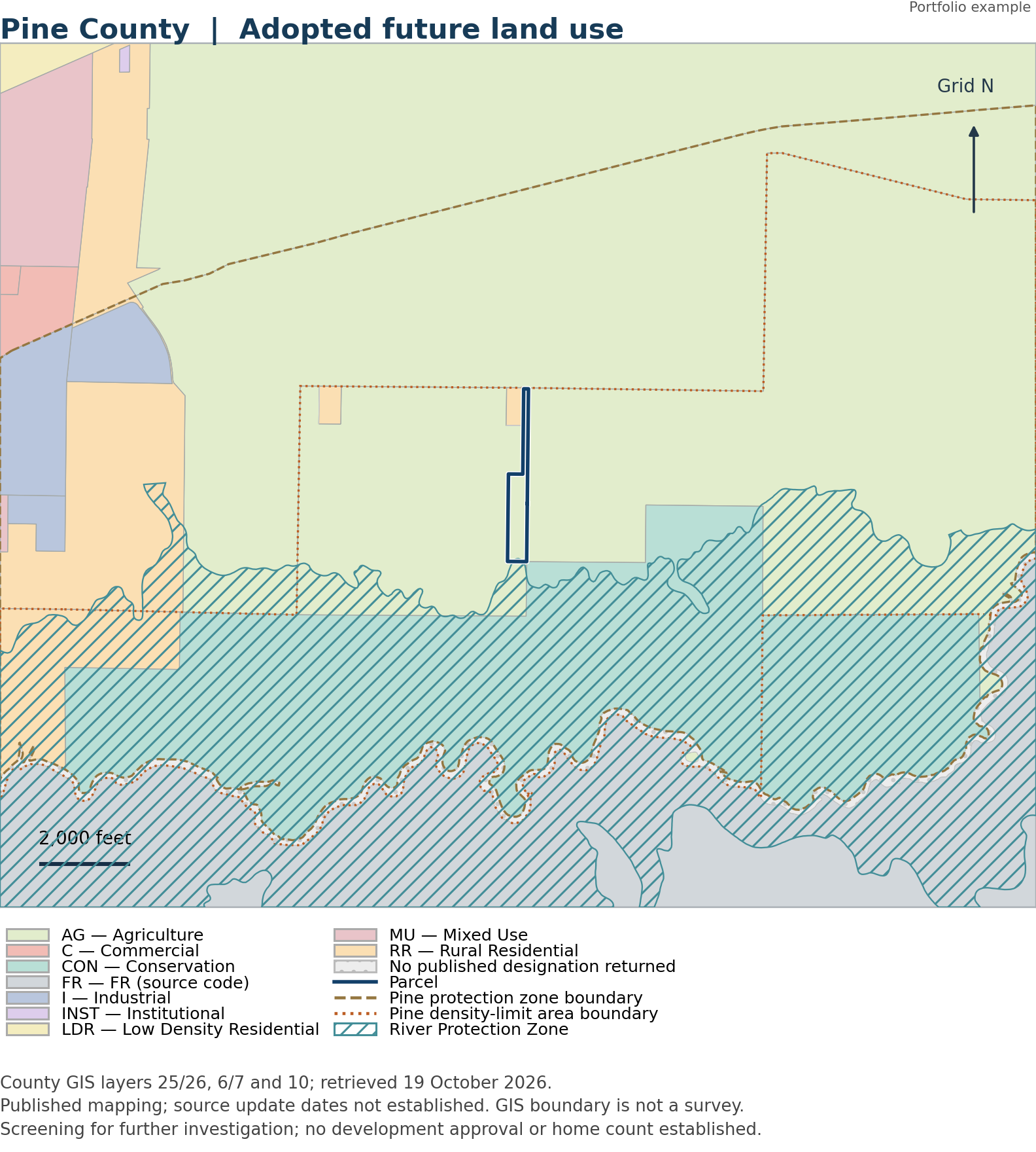
Agriculture covers most of the tract, with a smaller residential designation near the road. Additional density and protection provisions require county review.
Key takeaways
- Zoning and future land-use split boundaries differ slightly and need parcel-specific confirmation.
- Pine protection and density mapping covers the tract. The cited Agriculture provision includes a limit of one dwelling per 10 acres for this section.
- Ask the county to resolve controlling density, subdivision, overlay and river-protection requirements before relying on a residential layout.
Download the full report for planning tables and policy details.
Exhibit 3
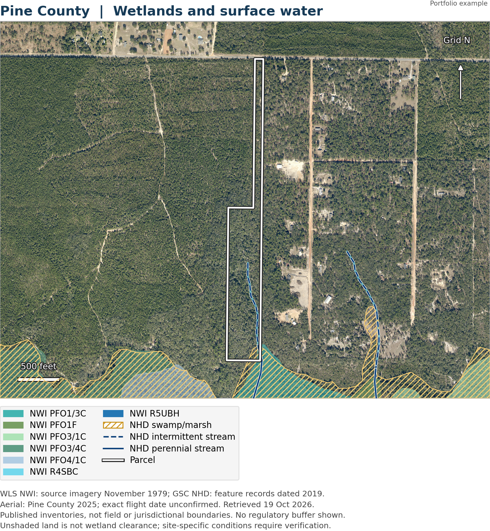
Wetlands and Surface Water
Published inventories identify forested wetland, streambed, stream lines and swamp or marsh features within the screening area.
Key takeaways
- Wetland inventory mapping relies on November 1979 imagery; current field conditions need confirmation.
- The mapped water inventories overlap and their acreages should not be added together.
- Have a qualified wetland professional delineate features and identify jurisdiction, crossing and permit questions before setting disturbance limits.
Download the full report for water-feature tables and limitations.
Exhibit 4
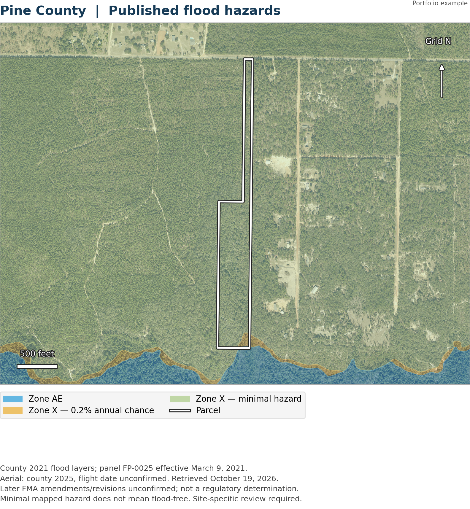
Flood Hazards
Small areas at the southern end intersect mapped Zone AE and the 0.2% annual-chance flood area.
Key takeaways
- Approximately 0.07 acre intersects Zone AE and 0.48 acre intersects the 0.2% annual-chance flood area.
- No mapped floodway intersects the parcel in the reviewed data. Minimal mapped hazard elsewhere does not resolve local drainage.
- Confirm the current flood panel, applicable map-change letters and project requirements with the floodplain office; verify elevations, culverts and access drainage.
Download the full report for flood mapping and review questions.
Exhibit 5
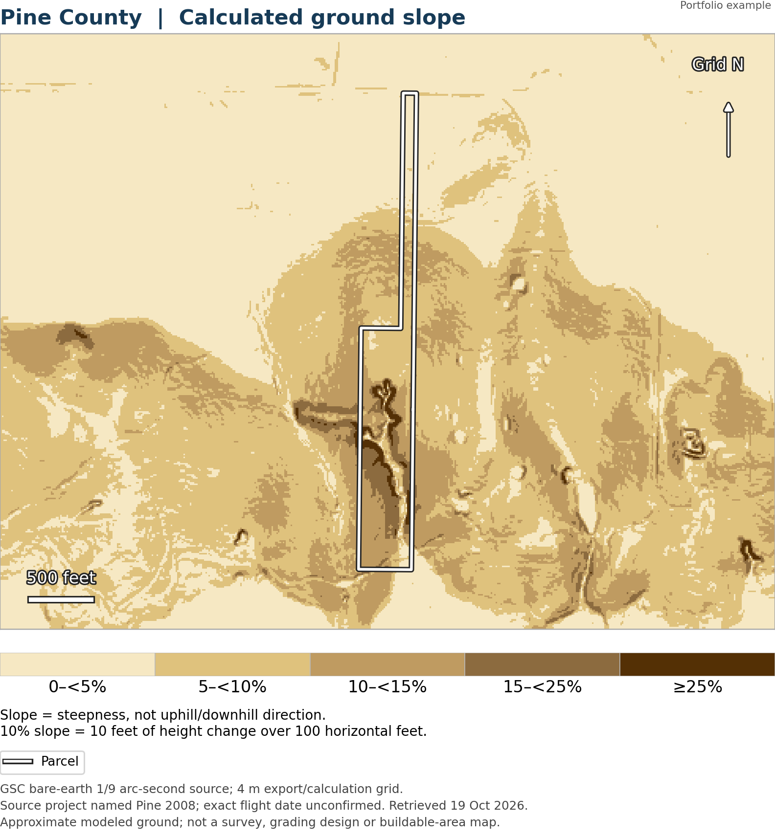
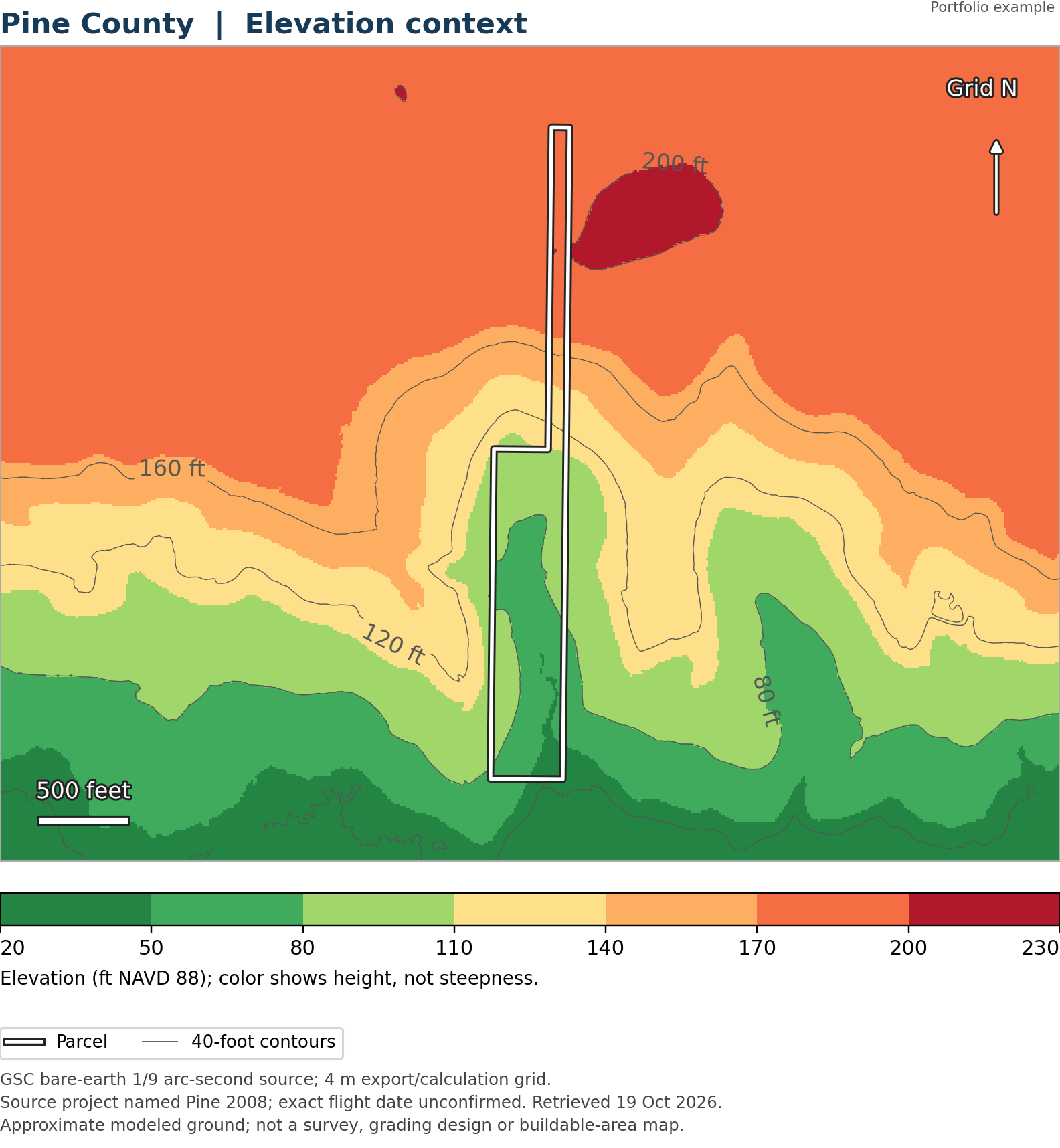
Terrain and Slope
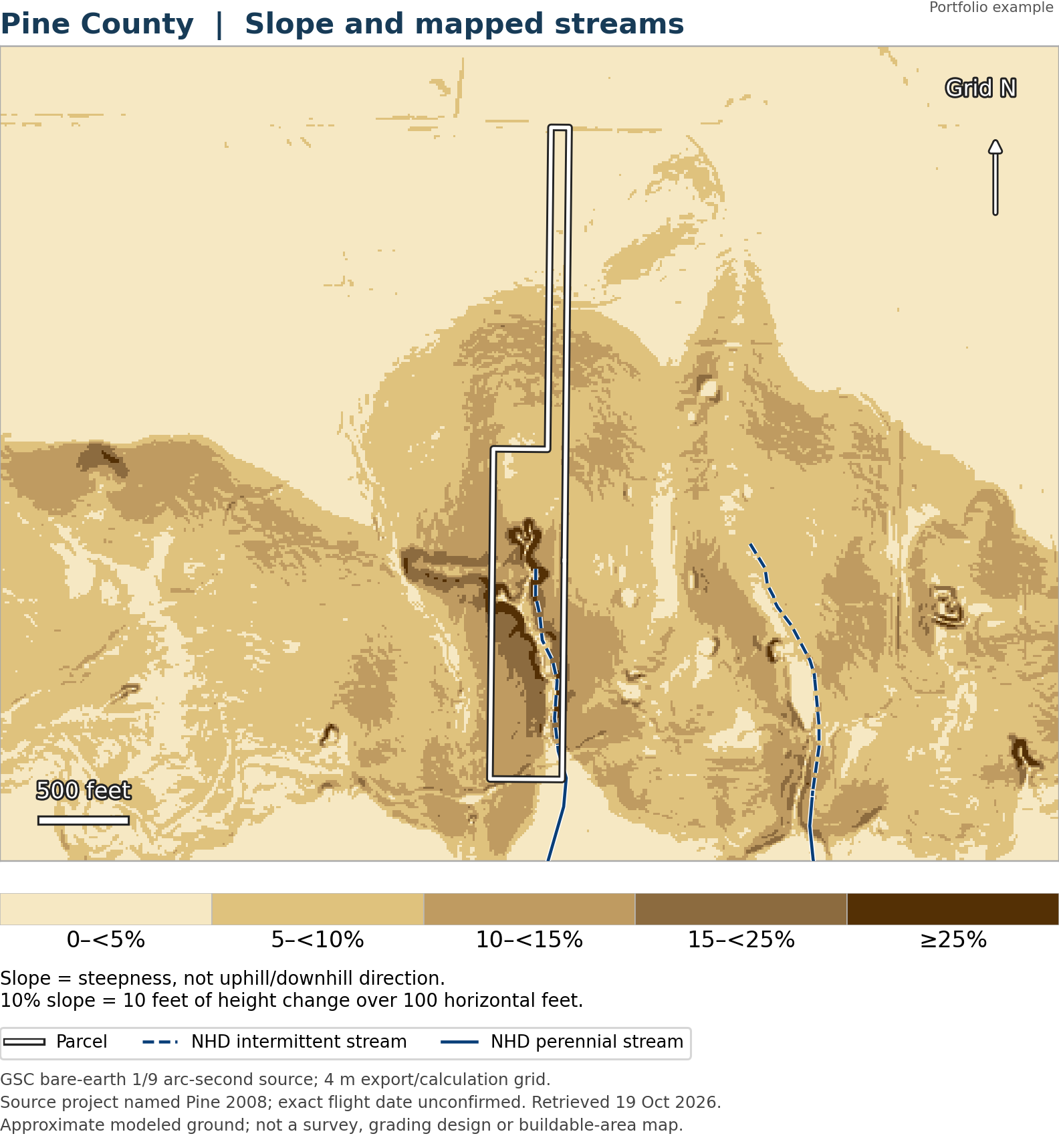
Modeled terrain generally falls from the northern portion toward the south, with substantial elevation change.
Key takeaways
- Modeled elevations range from approximately 41 to 200 feet.
- About 6.21 acres have slopes of at least 15%, including approximately 1.75 acres at least 25%.
- Obtain a topographic survey and professional review of access grades, crossings, drainage and proposed earthwork.
Exhibit 6
Water Supply and Wastewater Screening
A mapped public-water service area covers the parcel, but actual distribution, connection eligibility and capacity remain unconfirmed.

Key takeaways
- Request written confirmation of the water main, capacity, connection route, extensions and current charges.
- Current public-sewer availability is unresolved. Keep onsite wastewater investigation relevant unless a sewer connection is confirmed.
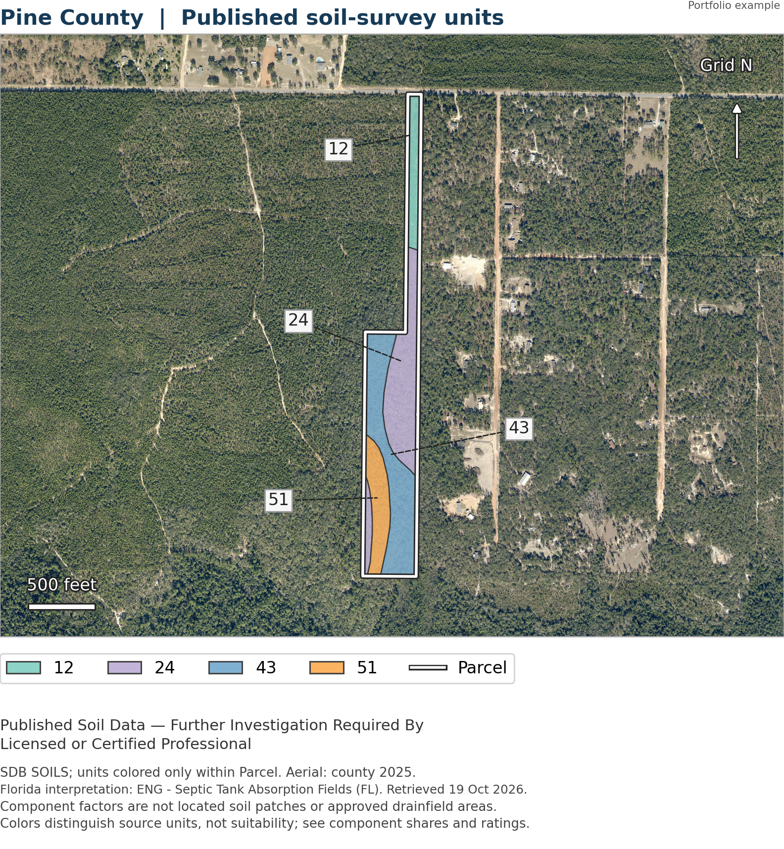
- Coordinate any well, drainfield and reserve-area investigations. Florida and national soil interpretations differ; the historical Florida rating basis is not a current permit.
Published Soil Data — Further Investigation Required By Licensed or Certified Professional.
Download the full report for utility findings, septic ratings and component tables.
Exhibit 7
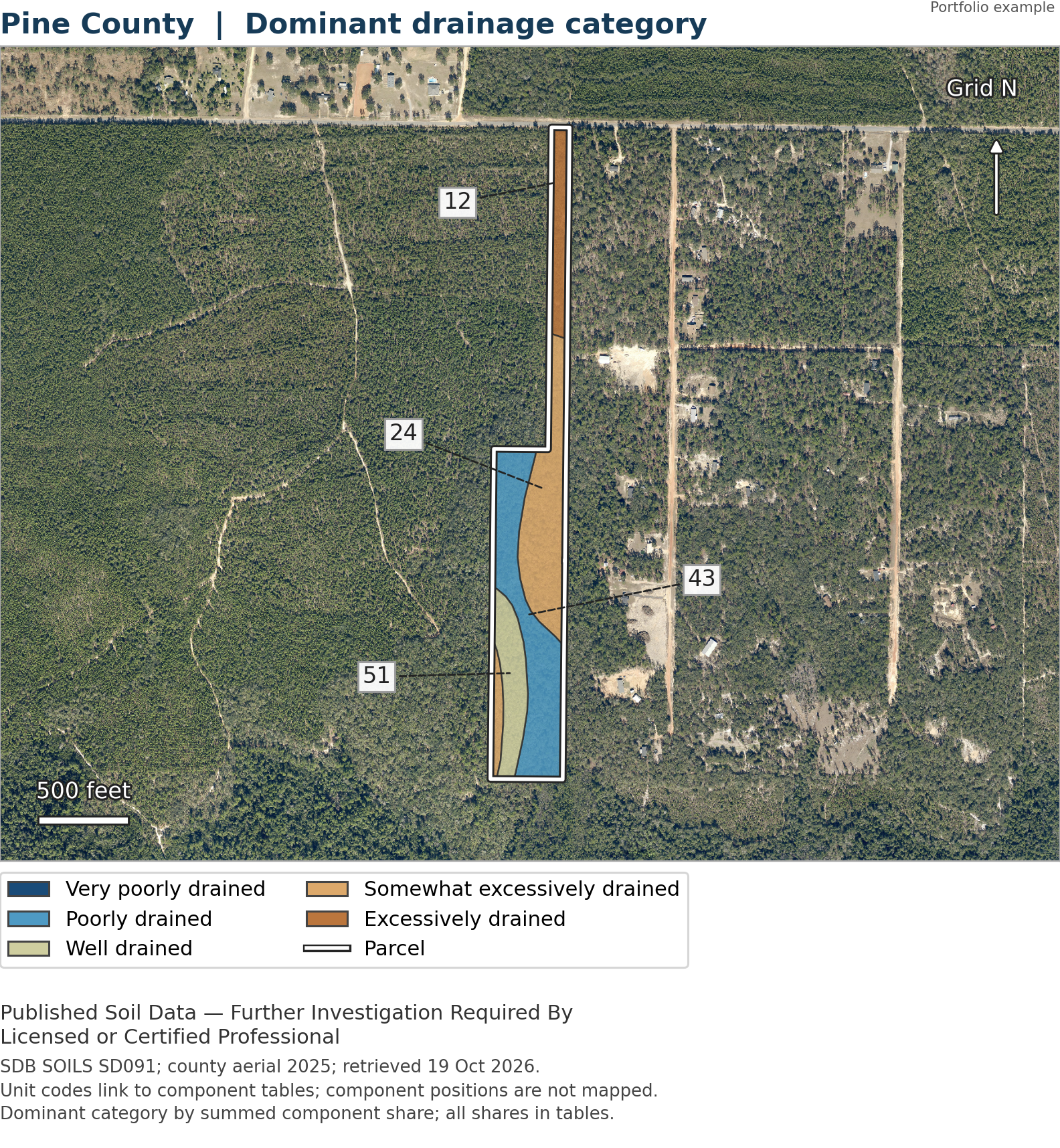
Soil Wetness and Drainage
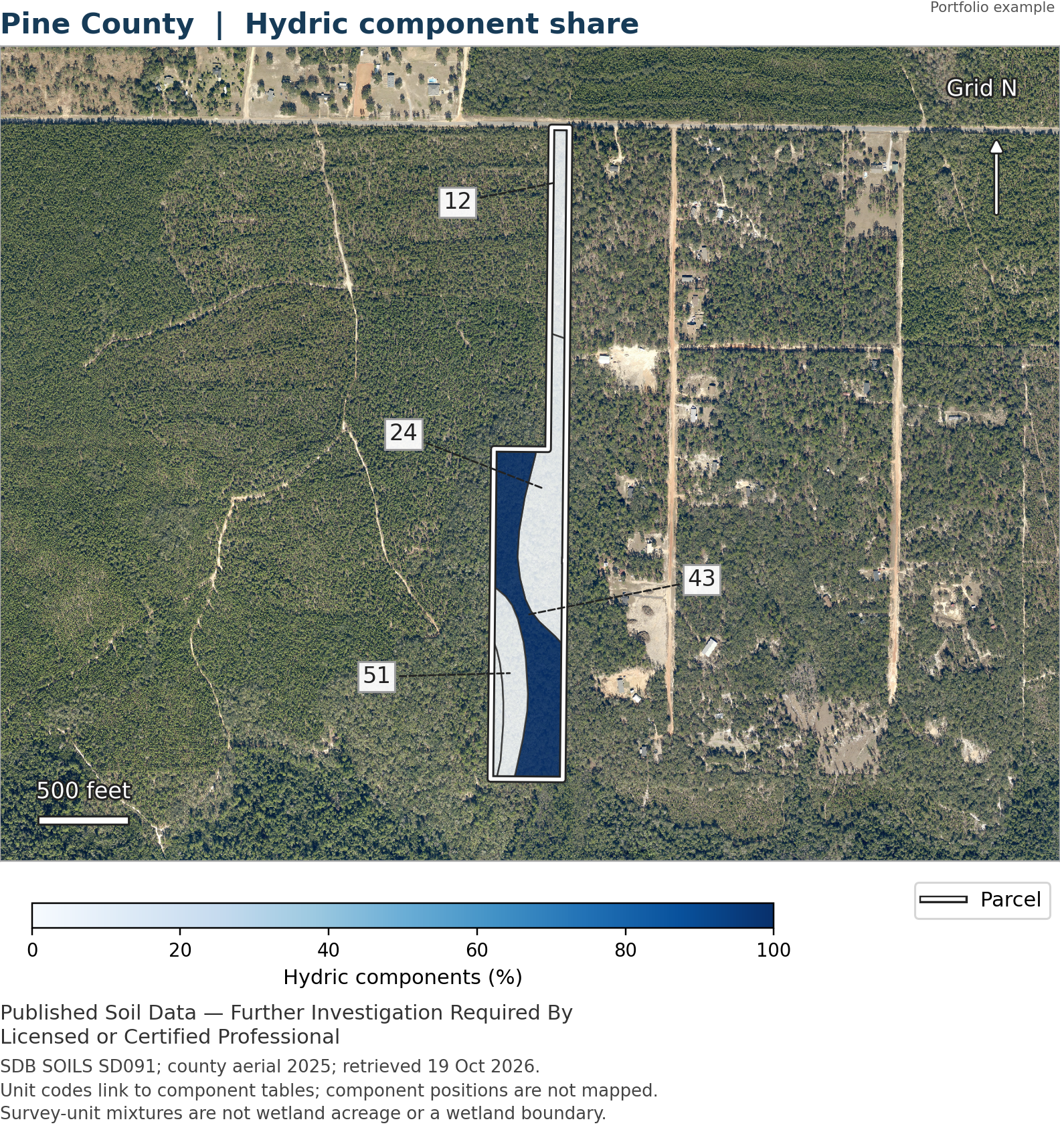
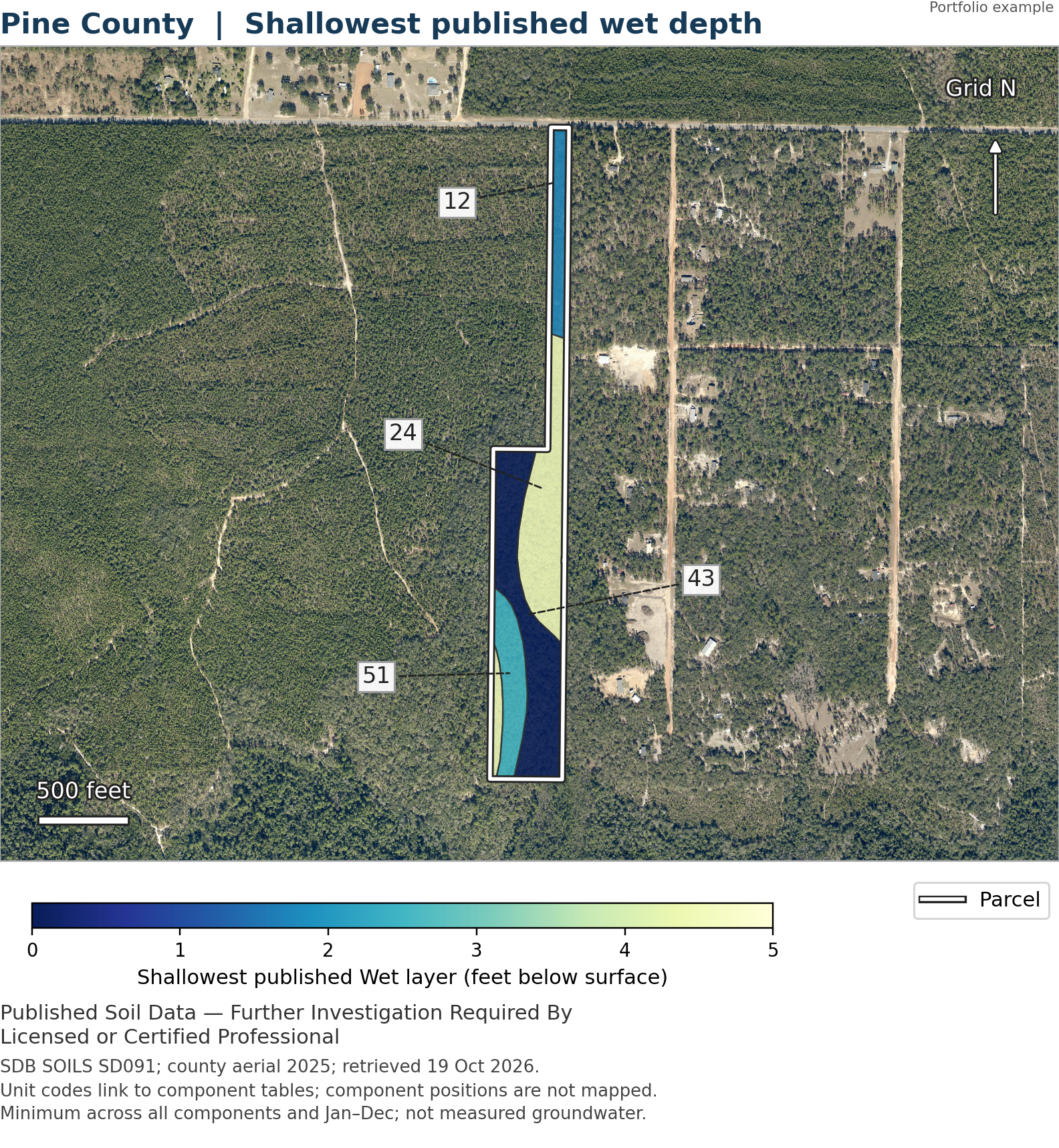
Published soil data identifies one hydric, poorly drained soil-unit mixture alongside three predominantly better-drained units.
Key takeaways
- Unit 43 covers approximately 9.27 acres and has 100% listed hydric components with a predominantly Poorly drained interpretation.
- Units 12, 24 and 51 have 0% listed hydric components; minor components still affect wetness interpretations.
- Field profiles and seasonal-water observations are needed at proposed buildings, access and onsite-system locations.
Published Soil Data — Further Investigation Required By Licensed or Certified Professional.
Download the full report for drainage, wetness and soil-component tables.
Exhibit 8
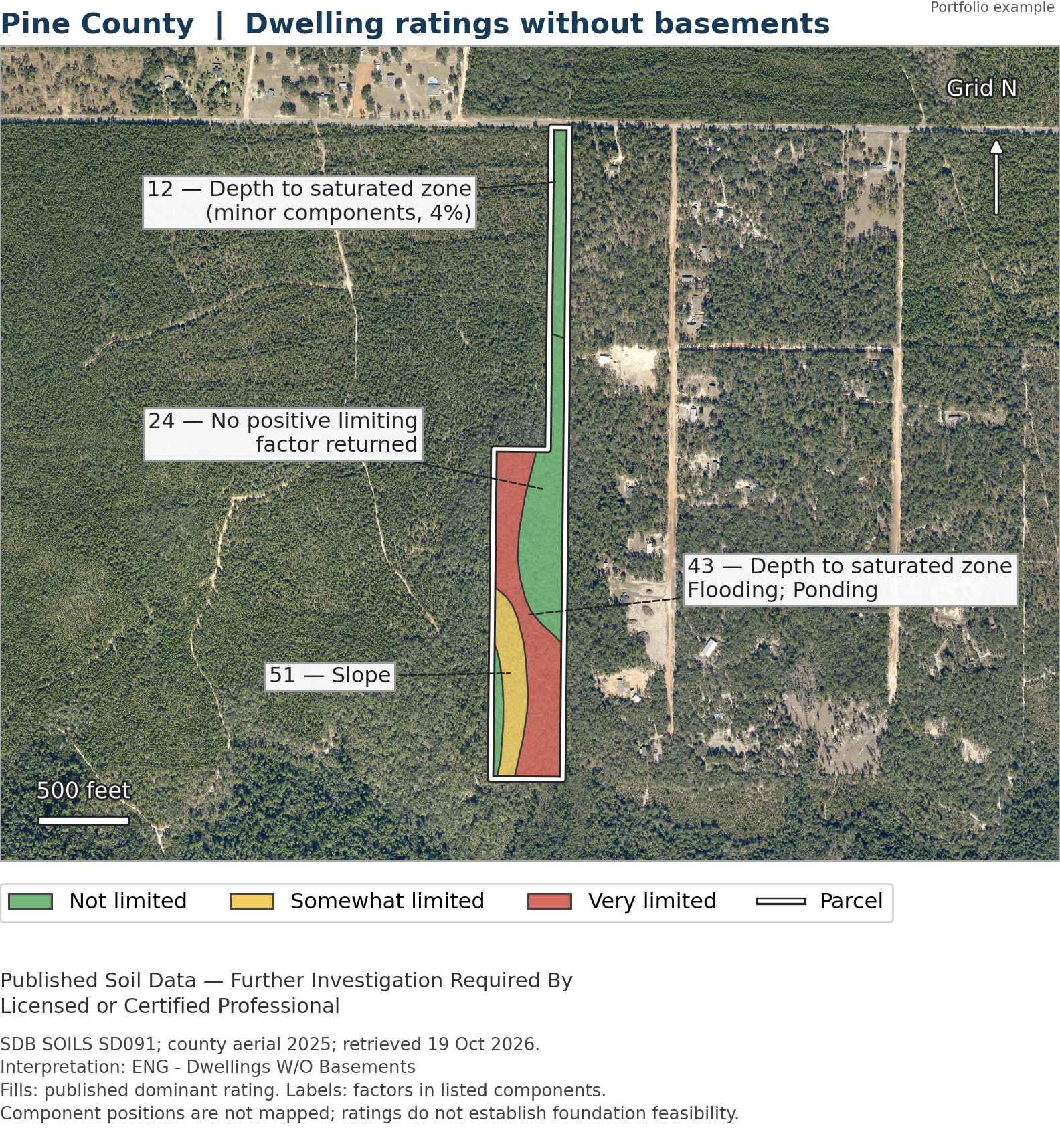
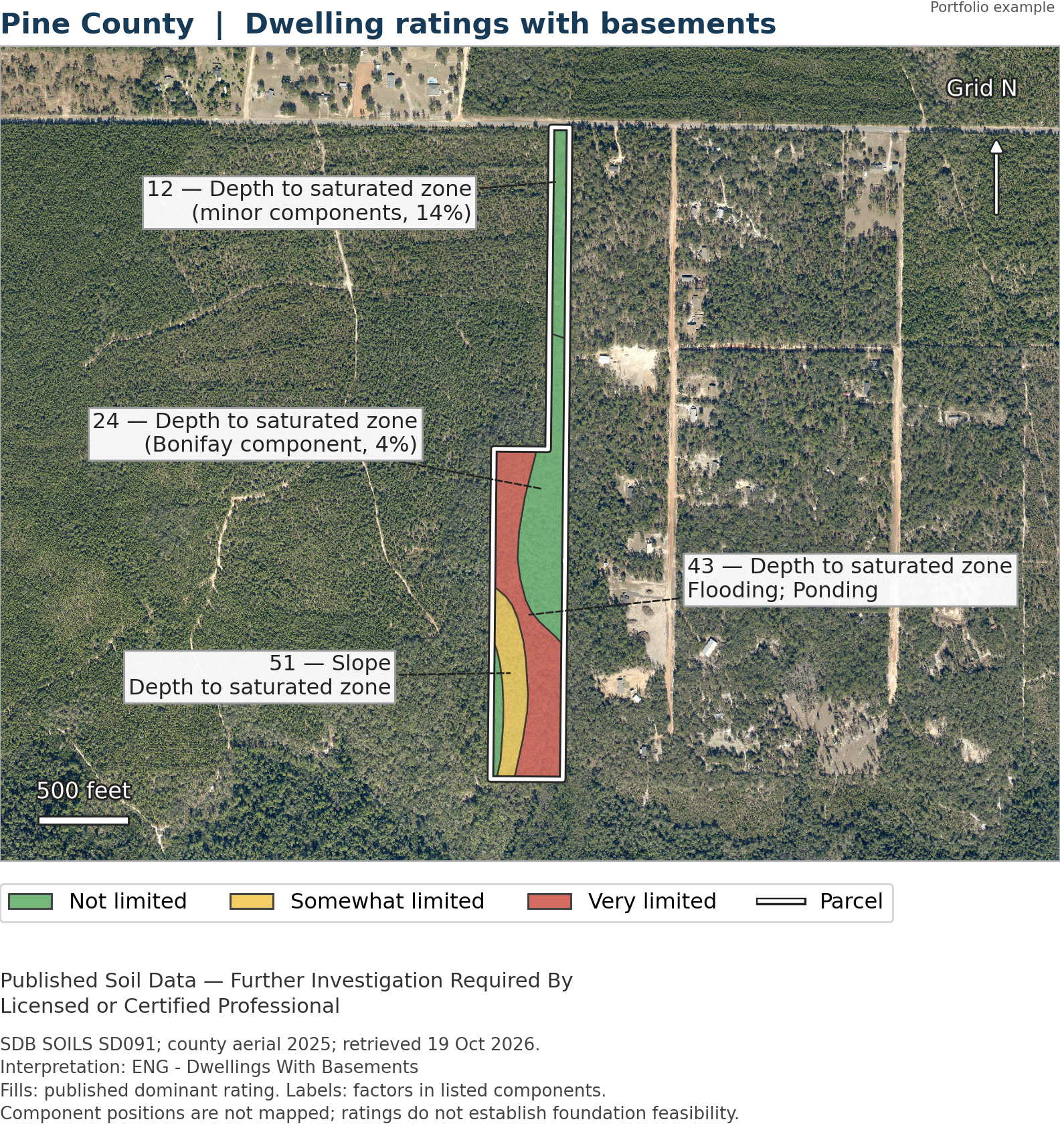
Building Soil Conditions With and Without Basements
Published dwelling ratings flag wetness and flooding in unit 43 and slope in unit 51.
Key takeaways
- Unit 43 is rated Very limited for both building scenarios.
- Units 12 and 24 are predominantly Not limited in the published model; unit 51 is mostly Somewhat limited for slope.
- Obtain site-specific geotechnical investigation and foundation recommendations before choosing building or basement designs.
Published Soil Data — Further Investigation Required By Licensed or Certified Professional.
Download the full report for building ratings, component factors and reference assumptions.
Exhibit 9
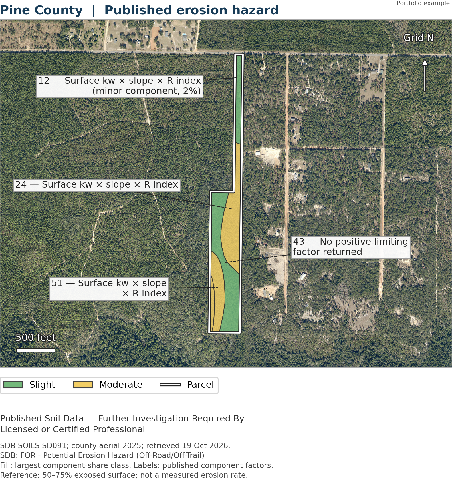
Clearing and Erosion
Published erosion ratings help focus review of proposed disturbance alongside steep terrain, vegetation and mapped waters.
Key takeaways
- Ratings are predominantly Moderate in units 24 and 51, and Slight in units 12 and 43.
- These model ratings do not predict construction sediment loss or establish where clearing is allowed.
- Coordinate clearing, stabilization and sediment-control planning with field drainage findings and current county rules.
Published Soil Data — Further Investigation Required By Licensed or Certified Professional.
Download the full report for erosion tables and model limitations.
Exhibit 10
Wildlife and Habitat
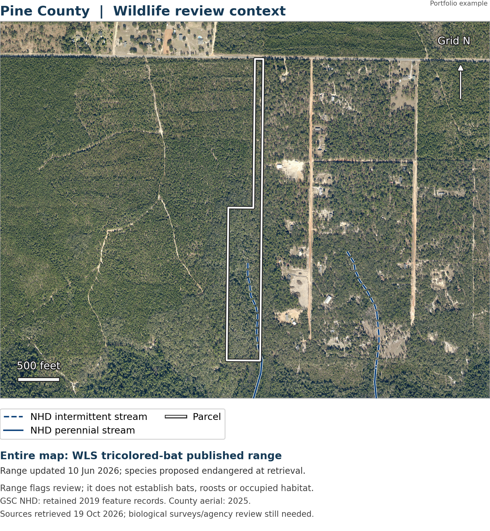
The published tricolored-bat range covers the full parcel and map view.
Key takeaways
- Reviewed regional critical-habitat data shows no parcel intersection.
- Range coverage and a lack of mapped critical habitat do not establish species presence, absence or clearance.
- Obtain qualified biological review and current agency guidance before relying on the screening for disturbance or permitting.
Download the full report for habitat findings and investigation questions.
Exhibit 11
Local Policies and Special Constraints
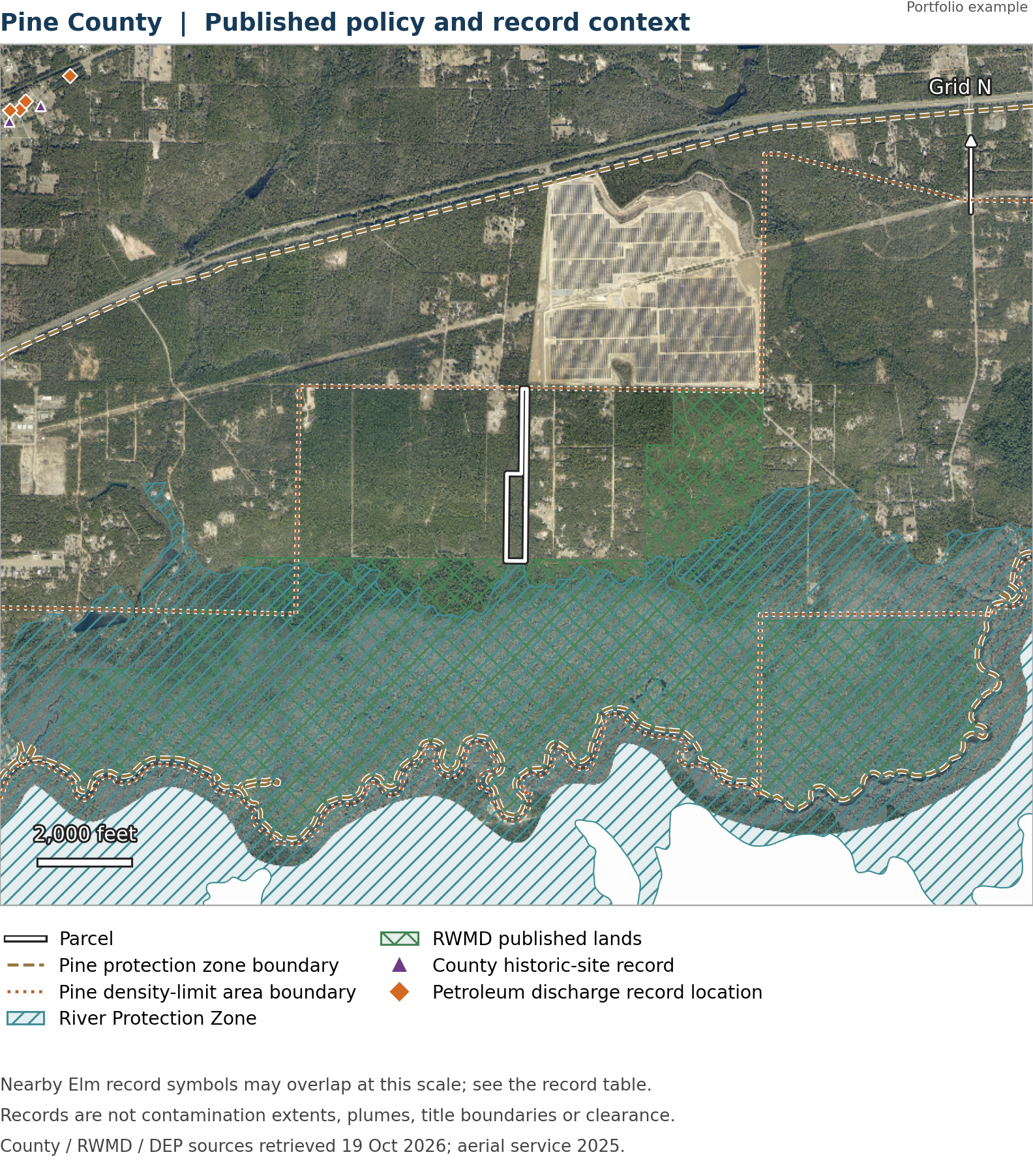
Published maps flag Pine review and density provisions, river protection and a small overlap with mapped water-management-district lands.
Key takeaways
- A River Protection Zone overlaps approximately 0.23 acre at the southern end.
- District fee-land mapping overlaps approximately 0.32 acre. Request acquisition and boundary records and reconcile the finding through survey and title work.
- Nearby environmental and historic records are investigation leads; proximity alone does not establish a parcel impact.
Download the full report for overlay details and nearby-record tables.
Exhibit 12
Ground Hazards
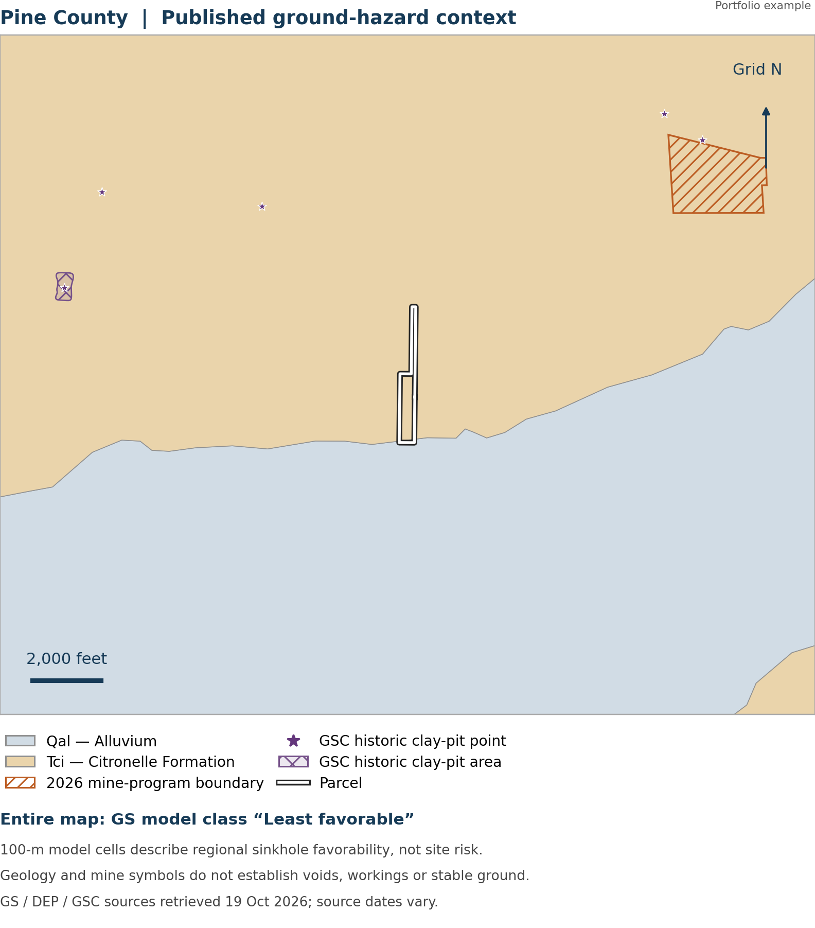
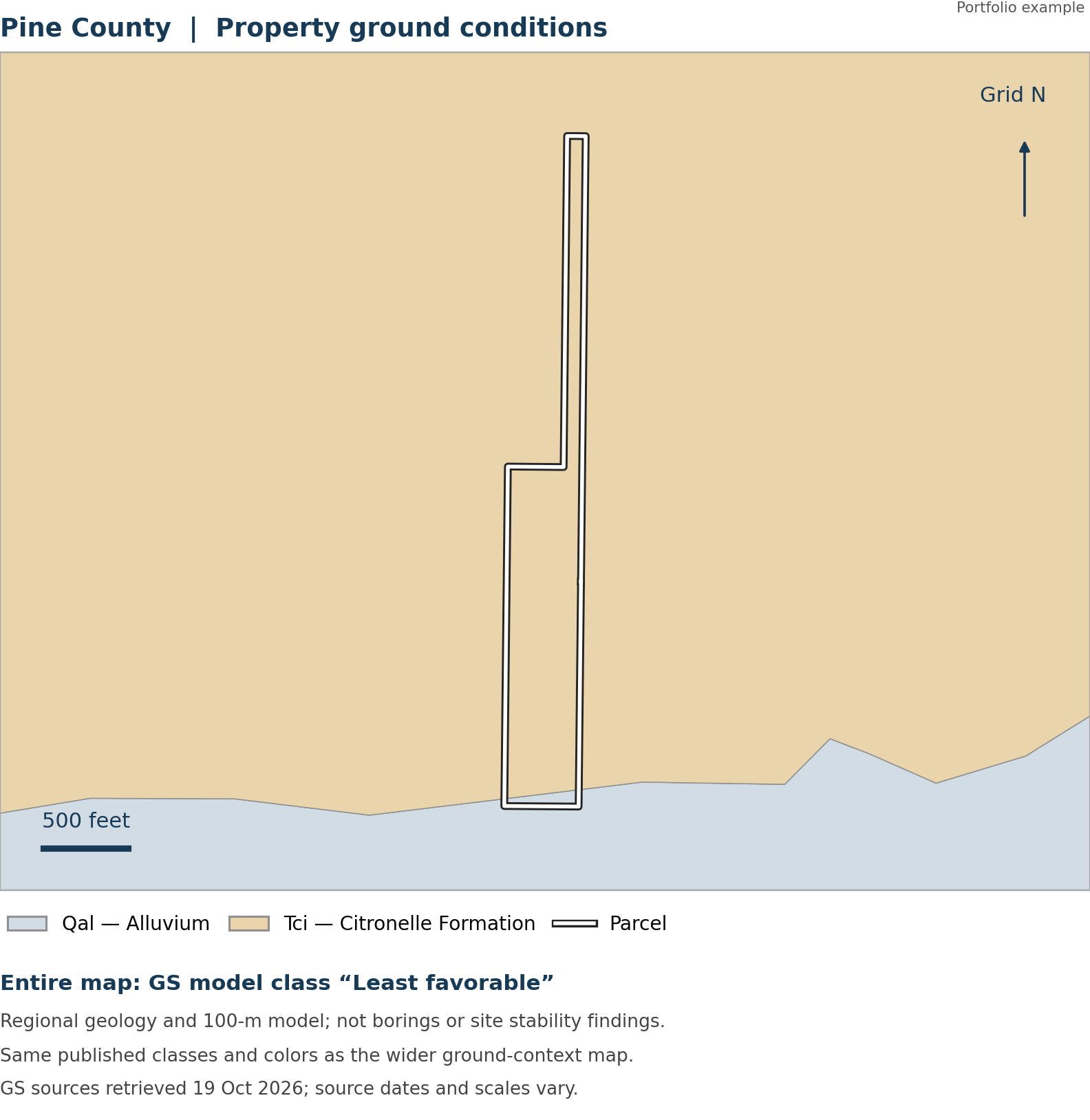
Regional geology, sinkhole models and nearby historical clay-pit records provide distinct leads for ground investigation.
Key takeaways
- Regional mapping places two geological units across the parcel.
- The state sinkhole model labels the parcel Least favorable, while an older regional map still describes possible cover-collapse events.
- Have a qualified professional investigate actual ground, fill and groundwater conditions for proposed cuts, fills and foundations.
Download the full report for geology, sinkhole-model explanations and historical records.
Exhibit 13
Surrounding Land Use Compatibility
County tax records show nearby residential uses, timberland and state or water-management classifications.

Key takeaways
- Confirm current neighboring uses and operations through site visits and local records.
- Review road and rail context, proposed access and neighboring activities for the residential concept.
- Confirm the responsible electric provider and project capacity; nearby energy facilities do not establish service.
Download the full report for surrounding-use records and follow-up questions.
Exhibit 14
Actions and Next Steps
The report turns screening findings into a sequence of investigations for purchase and residential-development decisions. Priorities describe sequence, not a risk score.
Priority 1
Confirm the property, sale limits, title and legal access. Resolve planning restrictions and establish the water and wastewater route.
Priority 2
Coordinate wetland, floodplain, terrain, soil, groundwater, habitat and ground investigations. Review nearby records and current conditions.
Priority 3
Combine confirmed findings into a residential concept, then refine agency review, engineering needs, infrastructure options and costs.
Download the full report for the complete action plan and exhibit references.